Showing posts with label training. Show all posts

Friday, December 17, 2021

The Making of a Historic Wind and Fire Event

The recent historic wind and fire event that literally blew through the Great Plains was anomalous in every sense of the word. But, not all anomalies are created equal. We see high-impact events all the time, but not all fall into the historic category. With today’s post I wanted to dig into some of the science behind this event and what set it apart from other high-end events.

Let’s first set the stage. A potent shortwave ejected out of the Central Rockies Wednesday morning, December 15, 2021, and very rapidly lifted northeast from the Central Plains into the Upper Midwest/Great Lakes by Wednesday night. Negatively-tilted shortwaves often mean business, and this one was no different.

What set this system apart from similarly-tilted shortwaves was the very strong mid-level jet that accompanied it. The observed 12z sounding at ABQ showed a 500mb wind speed of 100kt, while the observed 12z DDC sounding measured a 700mb wind of 65 kt. 


The 21z RAP 500mb analysis (shown earlier) suggested a peak mid-level wind speed of around 120 kt at 500mb as it moved out over Kansas. A mid-level jet that strong this time of year is more unusual.

Let me pause here a minute. Take a close look at that DDC sounding again. 


 On a day like this, with deep mixing expected, you can sometimes use an observed morning sounding to get a rough idea of how strong the winds might be in that area later in the day. In this case, the morning started with a fairly stout inversion across western and central Kansas, but the forecasted combination of daytime heating with cooling aloft (beneath the shortwave) suggested the potential to mix deeply, with the sounding revealing how strong the winds may be within that mixed layer. The DDC sounding, for example, showed 60-80kt in the potential mixed layer, suggesting peak wind potential of 80-90 mph for any area that could mix deep enough. The 21z RAP analysis reveals the areas from western to central Kansas where some of the deepest mixing occurred (shown by the steepest low-level lapse rates).

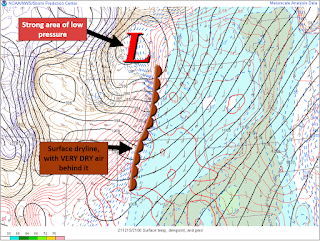
At the surface, an unusually deep surface low developed, adding a strong pressure gradient component to the wind potential. In Minnesota, the low pressure set arecord. The strong downslope drying east of the Rockies also helped setup a sharp dryline across Nebraska and Kansas.


The ECMWF’s Extreme Forecast Index (EFI) really helps put it all together. The EFI is a great forecasting tool to help determine which events may be anomalous. It can also reveal the anomalous events that are not like the others. 

On the map above, you’ll notice the EFI is maxed out (pink shading) over a large area of the Plains. Looking closer, though, you’ll notice a Shift of Tails (SoT) of 2. In my experience, that’s a separating marker between events. For wind, the combination of a high EFI value AND a SoT of 2 puts an area in a higher-end, potentially record-breaking, setup. The end result? A widespread area of verystrong, damaging winds. The wind, alone, was anomalous, but this event didn’t stop there.

When you overlap strong winds with a warm and very dry airmass, bad things tend to happen. This event appeared to be a classic fire outbreak setup, as researched and shown by Lindley,et al.


Adding fuel to the fire, literally, was very dry antecedent conditions. From an anomaly standpoint, there was a very large footprint of dry conditions across Kansas, with much of the state running 10-25%, or less, of normal for rainfall (since November 1, 2021). Fire weather aside, this also added to the risk of blowing dust.


Higher end fire weather days do occur on the Plains, but another aspect of this event that sets it apart is that it came in December. This December has been an active one for fire weather in Kansas. In fact, since 2006, only one other December was more active (2017). Outside of 2017, no other December in that time period even comes close.


Lastly, I want to highlight the anomalous combination of shear and instability, by December’s standards. The focus for severe weather was over the Upper Midwest, but it all started in the Central Plains. A plume of high PWats surged north through the Central Plains, ahead of the ejecting shortwave, and went well north all the way into, and through, the Great Lakes region. Getting that amount of moisture return that far north in December is a low frequency occurrence, and more unusual in December.


A moistening airmass beneath steep lapse rates and cooling temps aloft supported modest destabilization, and a weakening cap, ahead of the advancing dryline/Pacific cold front. This was accompanied by more than adequate shear for organized severe convection.


The shear/instability combo isn’t unusual for this part of the U.S., in general. In December, though? Not so much. An anomalous combination of shear and instability stretched from Kansas to Michigan, setting the stage for a remarkable swath of severe weather, including several tornadoes. And notice, once again, a Shift of Tails of 2 on the EFI plots below.

For perspective, Kansas, Nebraska, Iowa, and Minnesota have had more Severe Thunderstorm Warnings issued this December than any other December on record (dating back to at least 1986, based on IEM data). Since this post was focused on the science and anomalies of the event, though, I’ll leave the product climatology for another day. 

In summary, a truly historic, mid-latitude storm system had a “perfect storm” combination of high-end anomalies from top to bottom, and everywhere in between. Anomalous features regularly come around, but not all at the same time. Every now and then, though, they line up in perfect sync, often with devastating impacts. This post only touches the surface of the science involved in this event, but I hope it provided a little context to just how anomalous and unusual this event was over a huge footprint of the U.S., while also serving as a mini training moment for what to look out for in future higher-end wind and fire events. 

NOTE: Some of the mesoanalysis images shown above were from the NWS Wichita’s event summary. I helped make that summary, and the images I used in this blog are ones I made. I just wanted to clarify that in full disclosure to make sure it is understood that those images were not improperly taken from someone else's work.

Thursday, July 23, 2020

The Fearless Meteorologist


One of my favorite Craig Manning quotes (author of "The Fearless Mind") is, "When we start to focus on winning, we open the door to worrying about losing." (pg 28). I was thinking about this the other night after working a marginal severe event in our CWA.

While doing radar, thoughts of possibly losing began to creep in. What if I issue a warning that doesn't verify, or what if I miss a warning? What will others think of my warning decisions?


Thoughts are just thoughts, but if I dwell on those questions too much, worry can begin to steer my decisions. Worry seems to have a tendency to change our motive(s). My original goal when working radar is to provide the best service possible. When worry creeps in, that goal may begin to shift towards not losing. Manning argues that that may ultimately lower our ability to make good decisions (pg 5). I agree with him, but I also think there is an important clarification about winning.

What is winning? Is winning beating the models or having perfect warning verification? Is it getting all your neighboring offices to buy-in on a Target of Opportunity? Let's give perfect warning verification a whirl. Changing Manning's quote, we get, "When we start to focus on [perfect warning verification], we open the door to worrying about [imperfect warning verification]". Perfect warning verification is a great service, right?! Well, what about that storm with 80 dBZ up to 80,000' and strong mid-level rotation that is going over a very rural area? You warn on it, but because only 5 people and a cow live there, you never hear anything. Ding, ding, ding...an unverified warning. Good service, but imperfect verification. If your goal is a good service, you probably warn. If you're worried about losing, you may not warn. See the difference?


Manning isn't against winning, and neither am I. What's important is getting better. In Manning's words, "Winning is great—we all want to win—but winning takes care of itself if we keep improving." (pg 89) What I like about that is the mindset change. Focusing, instead, on improving implies there will be mistakes along the way...that we will lose at times. It's an acknowledgment that there is room to grow. By adjusting our mindset...we are committing to the best service possible through trying our best and improving where we're weak.


I realize this doesn't completely prevent worry from creeping in. Even with the change in mindset, I still find worry creeping into my decisions at times. But, in my experience, that change in how I think about "winning" has really helped to keep my focus on what's most important, even when I make a mistake.

ad more at https://www.brainyquote.com/topics/worry-quotes_3
"If you're doing your best, you won't have any time to worry about failure." - H. Jackson Brown, Jr

Tuesday, March 10, 2020

Sliced Bread and ZDR Arcs

New technology has always been exciting to me. As a teenager, I enjoyed reading through "Crutchfield" magazines to keep up with the latest and greatest in home entertainment systems. As a Meteorologist, I enjoy reading through journal articles to keep up with the latest and greatest in weather research. Some research catches on quick...others not so much. At the height of my home entertainment days, anything with "DTS" slapped on it got my attention. Dolby Digital...cool. DTS? Watch out! For surround sound, it was the best thing since sliced bread (in my mind). You could put DTS on an entertainment center and suddenly I'd be hooked.

The thing about a DTS label on an entertainment center is that it probably doesn't enhance the sound experience in any way. That's not to diminish the quality of DTS, or the quality of the entertainment center, it's just not the most appropriate application. On a similar note, only having Dolby Digital doesn't make a receiver bad, nor does having DTS make a receiver great. Is DTS the only way to go for sound? Nope. Had you talked to me about 20 years ago, though, I probably would have said yes.

The "DTS" of weather for me encompasses many new tools and technology, including GR, GOES 16/17, Dual Pol, and BUFKIT (yes, I realize all of those aren't brand, spanking new). High up on my list is Dual Pol. One of the forecaster's at my office often talks about the "story" weather data tells us. Dual Pol tells many...and I'm not convinced we've heard them all. What I find most fascinating about Dual Pol is the ability to help diagnose what storms are producing and how they are evolving, and the additional information this provides compared to legacy data, alone. Does it make legacy data bad or out-dated? Nope. But, I do believe it provides some additional clues that can improve our warning service at times.

A key to finding the best application of new research and tools seems to be rooted in how we view them. New tools are exciting and different, some of which truly are the best thing since sliced bread. An important differentiation is knowing which ones are proven and which ones have potential, but are not yet highly correlated, verified, etc. Personally, I'm guilty of 100% latching onto a new theory or tool at times, quickly trying to sell others on it. It's the next best thing...what are we waiting for?!

In reality, it may very well be the next best thing. But, until something is more solidly proven, we run the risk of an unhealthy view of the proven, yet not-as-new, methods. Ultimately, this could have unintended consequences. Successful warnings, for example, have come from legacy radar data, alone, but have also come from using a legacy and Dual Pol combination.

Having Dual Pol data is great, but it doesn't work perfectly in every situation. Like DTS, know when it can, and can't, be used. For me, I've found that figuring out when starts with admitting that it MIGHT not be the best thing since sliced bread. For those out there who are all-things-Dual-Pol like myself, don't let me lose you here. The point I'm hoping to drive home is to watch out for another case of Meteorological tunnel vision (something I am prone to).

I'm scheduled to present at my office's spring workshop this year, and I was ready to bust down the doors with ZDR Arcs and KDP foots. While research may yet reveal this to be true, I have had to slow my roll and realize that the data isn't 100% there yet to bust down any doors. When you bust down doors, you sometimes end up knocking people over in the process.

With new, or still-being-researched, tools, awareness (as opposed to selling) seems to be a better first step. And think about it...increased awareness can spark additional interest and research that may help in determining the needed viability of a tool. Sometimes we all just need to know a tool exists and how to test it. My hope at the workshop is simply to enhance awareness and let the research sell itself if, indeed, it is a better option. My hope is that I will be more intentional about checking, but not diminishing, my excitement for new research, and knowing when to sell something vs simply raising awareness.