Showing posts with label forecasting. Show all posts

Tuesday, November 22, 2022

Forecasting, Failure, and Football

The “Third Saturday in October” was a wild one this year, pitting #6 Tennessee vs #3 Alabama. For those who haven’t watched it with the family yet on your favorite streaming service, I’m about to spoil the ending. In what was a crazy back and forth game, the Volunteers took down the Tide, snapping a losing streak that dates back to my college days. #Success

As a Vols fan, why talk about failure, then? Let me explain…

I love analogies about as much as I love football. They resonate with me and help me learn and remember important ideas. They also help me get an idea across to others, hopefully in a more down-to-earth, practical kind of way. As I watched the field fill up with fans in Knoxville, I thought of failure and adversity and how that often precedes successes. I also thought about the importance of how we handle failure.

Failures come in all shapes and sizes. A tornado going unwarned is a big deal. It’s very visible, it can be costly, and really stings for both the person on radar, and the office team as a whole. It’s like a fumble in football. Then you have what I would consider small failures. For example, highs only reaching the 40s when you were forecasting 50s. It still matters, but it’s not as “visible” as a fumble.

For years, the Vols have put together some decent seasons with mixed success, but they could never get over that hump that was Alabama. They came close some years, but momentum has a way of knocking the wind out of you, and Tennessee has often struggled to not make mistakes and to not lose momentum. What struck me with this year’s game was how calm and collective the 2022 Volunteers squad was, even amid some significant adversity and failures. They played a great game, but there were some costly miscues. They squandered an 18-point lead in the first half, then late in the game, they fumbled the ball at their own 4 yard line giving Alabama momentum and an easy scoop-and-score. Vols fans everywhere thought ‘here we go again…’. But Tennessee didn’t go there again.

In the midst of several failures, the Vols never seemed to feel the weight of changing momentum. They picked themselves up and kept playing as hard as ever. One of the most poignant examples of this for me was when their QB (Hendon Hooker) got a rare sack. As he was being rushed, and with the pocket collapsing, he just sat down, almost as if to say, “You got me this time fellas”. He didn’t fight it, he didn’t scramble around trying to fix it, he just sat down. Then, he got right back up and went back to playing as if nothing happened. The late-game scoop-and-score gave the Vols another chance to get discouraged and lose heart, but they didn’t. They got right back on the field and returned the favor with another TD.

The Vols had a mix of big and small failures, but what set them up for success was how they handled the miscues. Like in football, momentum plays a big role in life. One small forecast mistake here and there probably won’t have a big impact on you. But one big mistake, or a series of consistent small mistakes? That can be a game-changer.

In my early NWS years, I came in all passionate about lots of things. I wanted to have an impact, and I thought my way was the best. The problem is, I let passion get ahead of people, and I burned bridges, some of which may never get fixed. That was a fumbled-the-ball moment (or really, several fumbles in a row) for me, and it still stings to this day. Like UT after the fumble return for a scoop-and-score, I’ve had to work hard not to let that mistake define my “game” (ie. my career). I hate that I made those mistakes, but I’m not doing myself or my NWS team any favors by dwelling on it. That mistake has taught me to better balance passion and people, but the only way I’ve been able to improve is to not camp in the past.

Then I think of the times on radar where I missed a storm, or warned on a storm that didn’t go on to be severe. Sometimes we just have to take a sack, then get right back up and keep doing our best. Tennessee’s QB getting sacked was a failure, but it doesn’t mean a lack of success. The real failure would be if Hooker gave up and stopped trying the rest of the game. Same goes with warnings. Where I’ve had to rethink my approach to success and failure is to realize that a missed warning due to laziness is not the same as a missed warning due to mis-reading the environment or a storm. When I mentor others on radar, I try to encourage them to focus on doing their best and to not stress about missed events. Craig Manning reminds us that “When you focus too much on winning, you’ll start worrying about losing.” ("The Fearless Mind"). We don’t want missed events or bad warnings, but we have to be careful not to beat ourselves up in an unhealthy way when we gave it our best shot, but a mistake still happens. 

I see success as trying your best, but also being aware of where you need some additional training or experience. I recently took more of a leadership position within the NWS. I know that I will make mistakes my entire career as a leader, but I’m setting myself up for failure if I worry about those mistakes. What sets me up for success is not fearing mistakes, but addressing them with myself and with others, honestly, as they come up. Mistakes give us an opportunity to improve if we let them.

Easier said than done at times, I know. Those big mistakes that sting can be really tough to come back from. Recently, the #4 Vols lost to an unranked South Carolina team. This loss hurts all the more because this essentially eliminates the Vols from a playoff opportunity. That failure is tough to swallow. While I still hold to the importance of not camping too long on mistakes, I also believe we have to give ourselves time to process them. You can’t pretend a fumble didn’t happen. It happened, you need to process it, then try to move on. Sometimes it takes a shift, a week, or a year, to move on. One way to help process mistakes is to think back on the successes. At minimum, the Vols will have their first 9-win season since 2016. That’s progress. Progress is filled with failures AND successes. We have to remember that.

Sometimes we need to have teammates come alongside us and help us get through a tough mistake. I have seen countless times where a teammate will come over and pat a guy on the helmet or shoulder after a costly mistake. 

Sometimes that player will still be slumped over on the bench for awhile while they process it, and we need to give people room for that, but they need to know others are there. We need teammates like that, and we need to be teammates like that.

I think about my young kids (we have 4!). I can coach them or I can yell at them. I’ve done both. I regret the latter when it happens, because it doesn’t help them, it only makes the mistake worse. If you are in a leadership position, are you coaching or yelling? How we handle personal failure matters, but it also matters how we handle the failures of others.

I’ll end on this. Success is great, but how we handle success matters as much as how we handle failure. We’ll have strings of mistakes followed by strings of successes. Those strings of successes are wonderful! But we have to guard against pride creeping in. A quarterback running around taunting his success, not the team’s success, isn’t healthy for the locker room culture. We can celebrate each other’s success, but in a way that doesn’t put all the attention on us.

Life is going to throw us some scoop-and-scores, sacks, and unanswered points. We are going to make mistakes. Some will be more subtle, while others will be as visible and as costly as a fumble. The lesson we can learn from the Tennessee / Alabama game is that how we respond to, and view, mistakes matters. To be the most effective at whatever we set our minds to, we have to play to do our best, instead of playing not to lose. Acknowledge where you’ve failed, improve where you can, and don’t get too hung up on where you dropped the ball. As we get better at responding to failure, we find freedom, fun, and less fear. And, that, sets us, and our team, up for long-term success.

Friday, December 17, 2021

The Making of a Historic Wind and Fire Event

The recent historic wind and fire event that literally blew through the Great Plains was anomalous in every sense of the word. But, not all anomalies are created equal. We see high-impact events all the time, but not all fall into the historic category. With today’s post I wanted to dig into some of the science behind this event and what set it apart from other high-end events.

Let’s first set the stage. A potent shortwave ejected out of the Central Rockies Wednesday morning, December 15, 2021, and very rapidly lifted northeast from the Central Plains into the Upper Midwest/Great Lakes by Wednesday night. Negatively-tilted shortwaves often mean business, and this one was no different.

What set this system apart from similarly-tilted shortwaves was the very strong mid-level jet that accompanied it. The observed 12z sounding at ABQ showed a 500mb wind speed of 100kt, while the observed 12z DDC sounding measured a 700mb wind of 65 kt. 


The 21z RAP 500mb analysis (shown earlier) suggested a peak mid-level wind speed of around 120 kt at 500mb as it moved out over Kansas. A mid-level jet that strong this time of year is more unusual.

Let me pause here a minute. Take a close look at that DDC sounding again. 


 On a day like this, with deep mixing expected, you can sometimes use an observed morning sounding to get a rough idea of how strong the winds might be in that area later in the day. In this case, the morning started with a fairly stout inversion across western and central Kansas, but the forecasted combination of daytime heating with cooling aloft (beneath the shortwave) suggested the potential to mix deeply, with the sounding revealing how strong the winds may be within that mixed layer. The DDC sounding, for example, showed 60-80kt in the potential mixed layer, suggesting peak wind potential of 80-90 mph for any area that could mix deep enough. The 21z RAP analysis reveals the areas from western to central Kansas where some of the deepest mixing occurred (shown by the steepest low-level lapse rates).

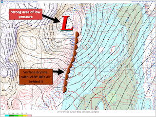
At the surface, an unusually deep surface low developed, adding a strong pressure gradient component to the wind potential. In Minnesota, the low pressure set arecord. The strong downslope drying east of the Rockies also helped setup a sharp dryline across Nebraska and Kansas.


The ECMWF’s Extreme Forecast Index (EFI) really helps put it all together. The EFI is a great forecasting tool to help determine which events may be anomalous. It can also reveal the anomalous events that are not like the others. 

On the map above, you’ll notice the EFI is maxed out (pink shading) over a large area of the Plains. Looking closer, though, you’ll notice a Shift of Tails (SoT) of 2. In my experience, that’s a separating marker between events. For wind, the combination of a high EFI value AND a SoT of 2 puts an area in a higher-end, potentially record-breaking, setup. The end result? A widespread area of verystrong, damaging winds. The wind, alone, was anomalous, but this event didn’t stop there.

When you overlap strong winds with a warm and very dry airmass, bad things tend to happen. This event appeared to be a classic fire outbreak setup, as researched and shown by Lindley,et al.


Adding fuel to the fire, literally, was very dry antecedent conditions. From an anomaly standpoint, there was a very large footprint of dry conditions across Kansas, with much of the state running 10-25%, or less, of normal for rainfall (since November 1, 2021). Fire weather aside, this also added to the risk of blowing dust.


Higher end fire weather days do occur on the Plains, but another aspect of this event that sets it apart is that it came in December. This December has been an active one for fire weather in Kansas. In fact, since 2006, only one other December was more active (2017). Outside of 2017, no other December in that time period even comes close.


Lastly, I want to highlight the anomalous combination of shear and instability, by December’s standards. The focus for severe weather was over the Upper Midwest, but it all started in the Central Plains. A plume of high PWats surged north through the Central Plains, ahead of the ejecting shortwave, and went well north all the way into, and through, the Great Lakes region. Getting that amount of moisture return that far north in December is a low frequency occurrence, and more unusual in December.


A moistening airmass beneath steep lapse rates and cooling temps aloft supported modest destabilization, and a weakening cap, ahead of the advancing dryline/Pacific cold front. This was accompanied by more than adequate shear for organized severe convection.


The shear/instability combo isn’t unusual for this part of the U.S., in general. In December, though? Not so much. An anomalous combination of shear and instability stretched from Kansas to Michigan, setting the stage for a remarkable swath of severe weather, including several tornadoes. And notice, once again, a Shift of Tails of 2 on the EFI plots below.

For perspective, Kansas, Nebraska, Iowa, and Minnesota have had more Severe Thunderstorm Warnings issued this December than any other December on record (dating back to at least 1986, based on IEM data). Since this post was focused on the science and anomalies of the event, though, I’ll leave the product climatology for another day. 

In summary, a truly historic, mid-latitude storm system had a “perfect storm” combination of high-end anomalies from top to bottom, and everywhere in between. Anomalous features regularly come around, but not all at the same time. Every now and then, though, they line up in perfect sync, often with devastating impacts. This post only touches the surface of the science involved in this event, but I hope it provided a little context to just how anomalous and unusual this event was over a huge footprint of the U.S., while also serving as a mini training moment for what to look out for in future higher-end wind and fire events. 

NOTE: Some of the mesoanalysis images shown above were from the NWS Wichita’s event summary. I helped make that summary, and the images I used in this blog are ones I made. I just wanted to clarify that in full disclosure to make sure it is understood that those images were not improperly taken from someone else's work.