Friday, December 17, 2021

The Making of a Historic Wind and Fire Event

The recent historic wind and fire event that literally blew through the Great Plains was anomalous in every sense of the word. But, not all anomalies are created equal. We see high-impact events all the time, but not all fall into the historic category. With today’s post I wanted to dig into some of the science behind this event and what set it apart from other high-end events.

Let’s first set the stage. A potent shortwave ejected out of the Central Rockies Wednesday morning, December 15, 2021, and very rapidly lifted northeast from the Central Plains into the Upper Midwest/Great Lakes by Wednesday night. Negatively-tilted shortwaves often mean business, and this one was no different.

What set this system apart from similarly-tilted shortwaves was the very strong mid-level jet that accompanied it. The observed 12z sounding at ABQ showed a 500mb wind speed of 100kt, while the observed 12z DDC sounding measured a 700mb wind of 65 kt. 


The 21z RAP 500mb analysis (shown earlier) suggested a peak mid-level wind speed of around 120 kt at 500mb as it moved out over Kansas. A mid-level jet that strong this time of year is more unusual.

Let me pause here a minute. Take a close look at that DDC sounding again. 


 On a day like this, with deep mixing expected, you can sometimes use an observed morning sounding to get a rough idea of how strong the winds might be in that area later in the day. In this case, the morning started with a fairly stout inversion across western and central Kansas, but the forecasted combination of daytime heating with cooling aloft (beneath the shortwave) suggested the potential to mix deeply, with the sounding revealing how strong the winds may be within that mixed layer. The DDC sounding, for example, showed 60-80kt in the potential mixed layer, suggesting peak wind potential of 80-90 mph for any area that could mix deep enough. The 21z RAP analysis reveals the areas from western to central Kansas where some of the deepest mixing occurred (shown by the steepest low-level lapse rates).

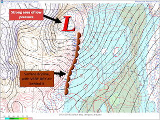
At the surface, an unusually deep surface low developed, adding a strong pressure gradient component to the wind potential. In Minnesota, the low pressure set arecord. The strong downslope drying east of the Rockies also helped setup a sharp dryline across Nebraska and Kansas.


The ECMWF’s Extreme Forecast Index (EFI) really helps put it all together. The EFI is a great forecasting tool to help determine which events may be anomalous. It can also reveal the anomalous events that are not like the others. 

On the map above, you’ll notice the EFI is maxed out (pink shading) over a large area of the Plains. Looking closer, though, you’ll notice a Shift of Tails (SoT) of 2. In my experience, that’s a separating marker between events. For wind, the combination of a high EFI value AND a SoT of 2 puts an area in a higher-end, potentially record-breaking, setup. The end result? A widespread area of verystrong, damaging winds. The wind, alone, was anomalous, but this event didn’t stop there.

When you overlap strong winds with a warm and very dry airmass, bad things tend to happen. This event appeared to be a classic fire outbreak setup, as researched and shown by Lindley,et al.


Adding fuel to the fire, literally, was very dry antecedent conditions. From an anomaly standpoint, there was a very large footprint of dry conditions across Kansas, with much of the state running 10-25%, or less, of normal for rainfall (since November 1, 2021). Fire weather aside, this also added to the risk of blowing dust.


Higher end fire weather days do occur on the Plains, but another aspect of this event that sets it apart is that it came in December. This December has been an active one for fire weather in Kansas. In fact, since 2006, only one other December was more active (2017). Outside of 2017, no other December in that time period even comes close.


Lastly, I want to highlight the anomalous combination of shear and instability, by December’s standards. The focus for severe weather was over the Upper Midwest, but it all started in the Central Plains. A plume of high PWats surged north through the Central Plains, ahead of the ejecting shortwave, and went well north all the way into, and through, the Great Lakes region. Getting that amount of moisture return that far north in December is a low frequency occurrence, and more unusual in December.


A moistening airmass beneath steep lapse rates and cooling temps aloft supported modest destabilization, and a weakening cap, ahead of the advancing dryline/Pacific cold front. This was accompanied by more than adequate shear for organized severe convection.


The shear/instability combo isn’t unusual for this part of the U.S., in general. In December, though? Not so much. An anomalous combination of shear and instability stretched from Kansas to Michigan, setting the stage for a remarkable swath of severe weather, including several tornadoes. And notice, once again, a Shift of Tails of 2 on the EFI plots below.

For perspective, Kansas, Nebraska, Iowa, and Minnesota have had more Severe Thunderstorm Warnings issued this December than any other December on record (dating back to at least 1986, based on IEM data). Since this post was focused on the science and anomalies of the event, though, I’ll leave the product climatology for another day. 

In summary, a truly historic, mid-latitude storm system had a “perfect storm” combination of high-end anomalies from top to bottom, and everywhere in between. Anomalous features regularly come around, but not all at the same time. Every now and then, though, they line up in perfect sync, often with devastating impacts. This post only touches the surface of the science involved in this event, but I hope it provided a little context to just how anomalous and unusual this event was over a huge footprint of the U.S., while also serving as a mini training moment for what to look out for in future higher-end wind and fire events. 

NOTE: Some of the mesoanalysis images shown above were from the NWS Wichita’s event summary. I helped make that summary, and the images I used in this blog are ones I made. I just wanted to clarify that in full disclosure to make sure it is understood that those images were not improperly taken from someone else's work.

Thursday, September 23, 2021

Backpack Leadership

Several years ago, I started to really get into leadership books. All have been very helpful for me in many different areas, but the one I’m reading now (“Developing the Leaders Around You” by John Maxwell) takes a little bit of a different approach compared to many of the others. Instead of a self-help approach, it’s more of an others-help approach. I’ve never heard someone refer to a book as being an others-help, but this one really is. It’s all about helping you (the reader) help others.

Meanwhile, I was listening to a podcast this evening that also hit on helping others. The hosts made a great analogy, likening helping others with lessening the load of a heavy backpack. They mentioned that each of us carry a backpack with some amount of weight in it. Throughout life, we will have opportunities to help shoulder the weight someone is carrying (a struggle at work, a loss in the family, etc.). That act, be it listening, lending a helping hand, covering a shift…it helps the other person, but can, oddly enough, help us. 

Think about it. Covering a shift for a coworker can be tough, but there can be a joy there as well. Maybe the weather is quiet and you offer to take some extra shift duties so that another forecaster can work on a project or upcoming presentation. Or, perhaps covering a shift for someone helps with their home/work-life balance during a busy week with the kids.

What has stuck out to me, lately, is how much of leadership is focused on others. John Maxwell argues that “The growth and development of people is the highest calling of leadership.”. When I first started reading this book, it kind of threw me off a little. I’m a big believer in servant leadership, but Maxwell really takes it to another level. He even goes as far as to say that some of the people we lead and develop will go on to be better at leadership and/or some other skill, than we are. Stings a little bit, doesn’t it? At least it does for me. 


There was an entry-level NWS forecaster I was helping train for a couple of years and it was really neat to see how quickly this individual progressed during that time. It brought a lot of joy to me to help shoulder that extra weight in their backpack (the extra weight that often comes with a new job). Towards the end of that initial training time, I remember a point when I realized this forecaster was basically climbing the mountain on their own. I’m a little embarrassed to admit it, but I recall thinking that this person was going to be more skilled than me at this rate. I started running into a little bit of a self-conscious wall. The focus began shifting away from training a fellow coworker, and instead to an unhealthy focus on myself.

I’m sure that John Maxwell knew this would be an issue for some of his readers, like myself, and I'm so glad he addressed it. He points out that “To be a great developer of people, you must be personally secure, because taking…people to the height of their potential may mean they will pass you by.”. This forecaster was passing me by and I had to be ok with that. Why? Because that's what leadership is about.

What I’m seeing more and more is that leadership is not about being better than others at something, it’s not about being a higher grade, it’s not about getting extra freedoms or having fewer people to answer to. Leadership is about others. It’s about serving others, it’s about providing resources, it’s about giving opportunities…it’s about setting others up for success. For me, it’s giving up radar (which I love doing) and, instead, doing routine duties (not as exciting) so that someone else can have an important learning opportunity. It's about giving up my favorite sit-stand workstation because it's vital to another forecaster's success on a midnight shift. It's about having that tough conversation about a disagreement or problem. It’s about effectively leading a shift in a way that makes the environment as peaceful as possible, even when things are going sideways. “Lead people, manage things” John encourages. Sometimes leadership is about being hopeful and helping keep morale up, a task which can be very difficult!

And no, this doesn't mean you never focus on yourself. John points out that there is an important aspect of leadership that does involve ourselves. Are we learning, are we improving, are we leading effectively? I would add...are you taking time for yourself to just rest and relax at times. Those are important questions to regularly address. What has struck me, though, is that leadership is not about my position, popularity, or level of technical skill. The challenge for me is daily making sure that my actions and motivations stem from a genuine care for others.

Looking around, some of the best leaders I’ve ever worked with are the ones who made leadership about others. Those are the leaders who have had the greatest impact on me, and that is the leader I want to be.

Saturday, July 31, 2021

Sandbagging the Delta

In the fall of 1992, the stage began to be set for a flood that would eventually devastate farms, towns, and livelihoods along the Mississippi River Valley during the summer months of 1993. As the waters rose throughout the Central U.S., people took action, not just to save their homes, but also the homes of others.

Of all the stories I read of people helping others, one man summed it up nicely. He said, “I was 20-21 at the time and saw what one person could do for many.” (1) As a Meteorologist, I don’t enjoy seeing devastation from weather events, but what never grows old is the way people come together to help others. Time and time again I’ve watched people help each other no matter what their race, religion, or economic status is. The damaging effects of weather are somehow slightly brightened by people putting aside their differences to help a fellow human being out. Listen to some of these accounts from the summer of 1993…

“I spent most of that summer sandbagging, filling sandbags and going to where help was needed.”

“… A friend and I joined about 10 strangers and off we went to sandbag.”

“A call went out to volunteer on the wall in Germania, so I went. This wall was big, had pumps behind it to relieve pressure, and we were defending dozens of homes. … Easily 30-plus people were on the line moving thousands of bags. Anyone could have been on that line, from high school drop-outs to college graduates. The only thing that we had in common is that we all stunk of sweat and smelled the ripe water on the other side of the wall.

“I spent every evening from 8 p.m. to 2 a.m. sandbagging” (1)


Words like “strangers” and “only thing in common…” stand out to me. People were helping each other whether they knew them or not. Humanity helping humanity. It’s a sight to behold and is a thing of beauty.

Tomorrow, August 1st, is the anniversary of the peak river stage along the Mississippi River near St. Louis, and it got me thinking of how I could help my fellow man and woman in this flood of COVID. My wife and I decided to get vaccinated earlier this year and “sandbag” our home, so to speak. But, I feel like our help doesn’t stop there.

It appears that the Delta variant of COVID is like a renewed rise in flood waters, putting certain communities at risk once again. I had hoped the flood waters were receding for good, but it appears that may not be the case. Just like people coming together during the summer of 1993, I don’t just want to ask what I can do to help my house. I want to find ways to help the community as well. My home may be at lower risk of impact, but this is a community-wide fight.

So with that, my wife and I have decided to start wearing masks in public once again, not in fear and not because it’s required, but in support of our community. We care for our community and want to do our part to help fight against the potential renewed flooding that is COVID and the Delta variant.

At this point, I hear some probably questioning whether COVID is as big of a problem as some make it out to be. I hear you on that, and sometimes I wonder that myself. However, as a Meteorologist, I regularly see people not take certain weather events seriously, sometimes with devastating consequences (this storm won’t be as bad as the last one, tornadoes never strike here, etc). Some even laugh it off (ever heard of hurricane parties?).

Unfortunately, we don’t have the luxury of knowing in advance exactly what will happen with a weather event or with the Delta variant. And so we each have to make a decision on how to prepare. But, I believe that the decision doesn’t stop with us. We may not all agree on the severity or impact of COVID, we may not all share the same race, religion, or political background, but we do all share one thing…we are all part of humanity. So, maybe the question we should ask ourselves is what can I do for my community? My wife and I have asked that question and made our decision, and will continue to re-evaluate that decision. Will you join us and do the same? I’m not asking others to make the same decision we did, but I would challenge those reading this to ask what is best for your community during this time. Just like during the Flood of ’93, helping your community may be uncomfortable, annoying, and inconvenient. But, in the end, humanity helping humanity is a beautiful thing and has a way of turning enemies into friends. 

My hope is that we, as a human race, will find a way to come together during this time, community helping community, neighbor helping neighbor, thinking not only of ourselves and our personal rights, but of others, too. What an amazing opportunity we have.

References

(1) “Readers Share their Memories of the Flood of 1993”. St Louis Post Dispatch, 11 August 2013. https://www.stltoday.com/news/local/metro/readers-share-their-memories-of-the-flood-of-1993/article_9982bbaf-8981-5b4b-adb1-4a6b11653b75.html. Accessed 31 July 2021.

Sunday, June 27, 2021

Baseballs and Caps - Messaging Uncertainty

Imagine yourself at the forecast desk, or about to brief partners, or working up a “Key Takeaways” graphic for social media. You’re looking through various model guidance and you see a very consistent trend for a very concerning environment over the next 24 hours, characterized by extreme instability (4000-5000 j/kg MLCAPE), modest shear (30-35kt effective), weak inhibition (-25 j/k CIN), and very steep lapse rates (8-9 C/km). It’s the kind of environment you tell your spouse to keep the flashlight and basement handy. But, there’s a caveat. You can’t find any appreciable large-scale forcing for ascent and low-level convergence is weak, at best. Oh, and there’s a little ridging building in aloft. It’s one of those very conditional, but non-zero threats. The thing is, we’re not talking about a conditional threat of pea size hail and 30 mph wind gusts. This is a conditional threat of baseballs, 80 mph wind gusts, and the occasional EF-3 tornado. It may be that only one storm forms, but the impact would be high. But, from a probabilistic standpoint, it’s likely that people will see puffy clouds and experience a hot, muggy, storm-free day. What do you do?

It’s a not-to-uncommon question faced by Meteorologists on the Plains, especially in the transition from spring to summer patterns, where instability is trending higher, but the stronger flow aloft is shifting away from the area and forcing is weak. It’s a target of opportunity that probably deserves some attention, but how much?

This week I begin my fourth year forecasting the weather in the Central Plains, and I still have a lot to learn. These conditional high-impact days are intriguing, a challenge to forecast, and carry a lot of weight. If you tell people severe weather is possible, will they treat it like it’s likely? Does the crying wolf syndrome come into play? What if you skip messaging the low probability of occurrence, but then it happens? Which is worse, crying wolf or “it hit without warning”? Maybe the answer varies by region of the country? Maybe there isn’t a one-size-fits-all-regions answer.

There are a lot of factors at play here, some of which social science probably gives us the best avenue moving forward in an increasingly probabilistic realm of messaging.

I recently asked some fellow Mets, on Twitter, what they thought this scenario (if interested, you can read the thread to see the discussion). Something in that discussion that struck me was our ability, as Meteorologists, to message the environment. We focus a lot on messaging the forecast, but I’m seeing more and more that the message can’t stop there. Dr. Julie Demuth suggests that we “stop thinking of a given forecast as the end-point and start thinking of it as the starting-point for a conversation.”. In our scenario above, our users are seeing a low probability of storms in our forecast, but do they understand the magnitude of severe weather that could occur if storms do form? I wonder if targets of opportunity extend beyond just our forecast grids. Maybe the environment, itself, is a target.


We may not change our forecast, but we might consider changing our messaging.

Three years ago this month, I worked a shift that featured a conditional, high-impact environment.  I ended up working a 13 hour shift that day…a day that included baseball size hail and an EF-3 tornado. Three years later, I worked a shift with a similar conditional threat with a very similar environment. That shift ended on time, and did not include any baseballs or tornadoes. Two shifts with a similar, high-impact potential, but with drastically different outcomes.

Probabilistic forecasting isn’t exactly new for Meteorologists, or even our users. However, it appears that we are moving into an advanced realm of forecasting and messaging that has a higher ratio of probabilistic to deterministic info, with a learning curve both for us and for our users. I get the sense that there isn’t one right answer for all scenarios, but I still am not sure where to land on these “fringe” events, so-to-speak. I’m hoping continued discussion, group-think, trial and error, user feedback, and social science findings will help us as we continue to seek effective messaging of low-probability events.

If you have any ideas, suggestions, or comments on this topic, I’d love to hear them! Comment on the post, shoot me a message, or add to the Twitter discussion. We’re better off if we learn together.